- March 8, 2013
District Neelum:
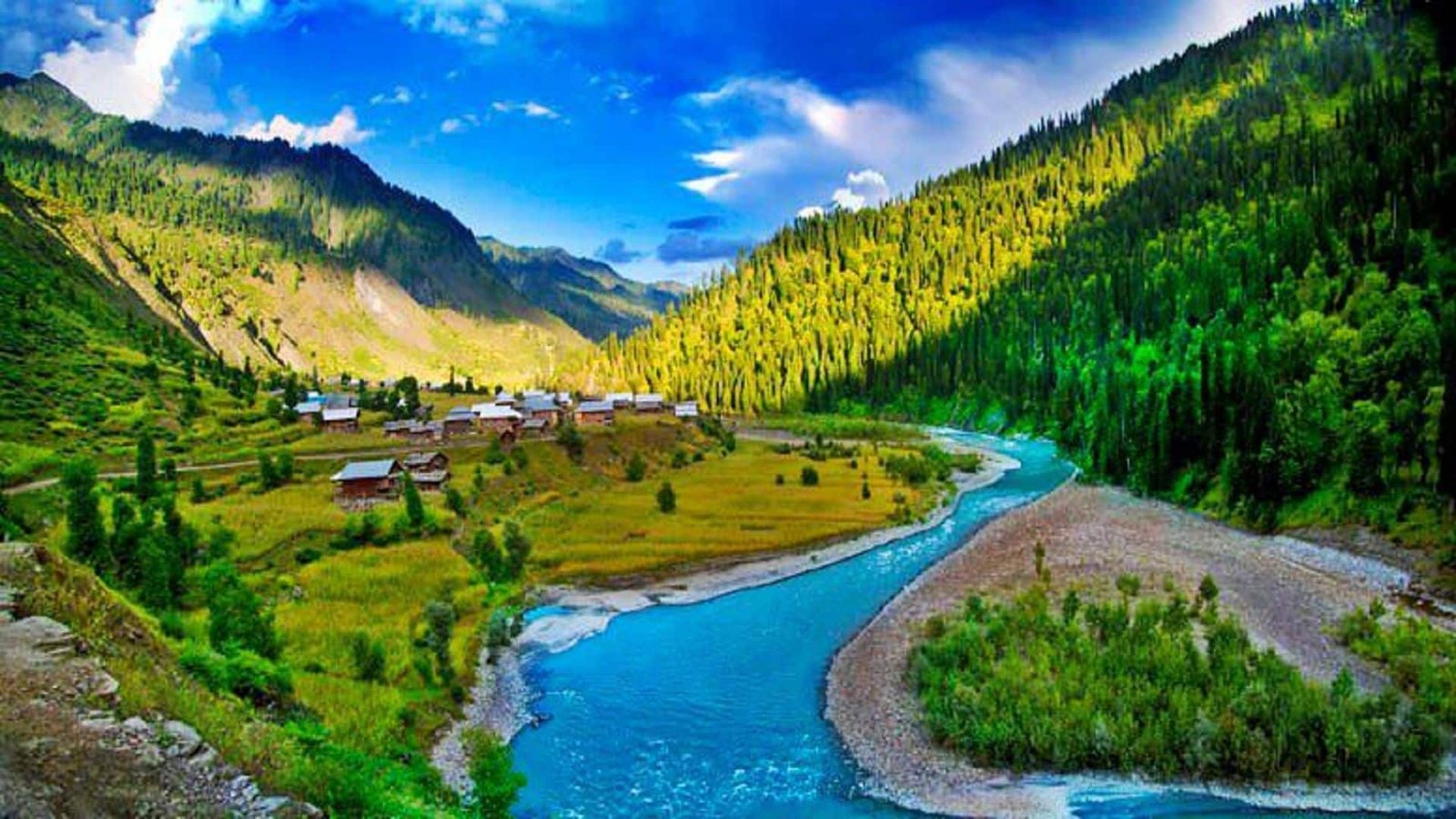
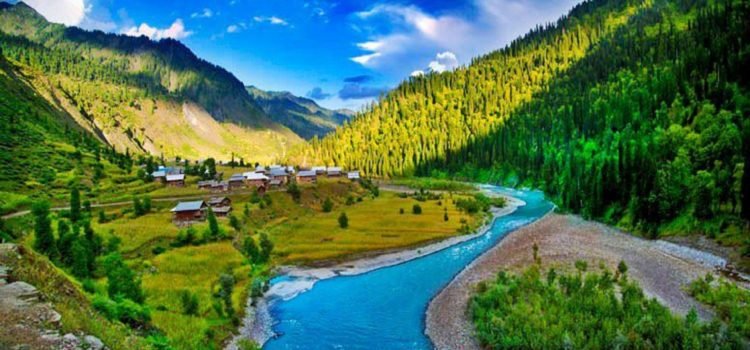
About 240 kilometers long the picturesque District Neelur Valley is situated to the North & North East of Muzaffarabad (Running parallel to the Kaghan Valley it is separated from it t snow covered peaks, some over 4000 meters above sea level. Excellent scenic beauty, panoramic view, towering hills on both sides of the noisy Neelum river, lush green forests, enchanting streams, high altitude lakes and attractive surroundings make the valley a dream come true.The area is also ideal for mountain tourism. A part of Nang Parbat Massif Falls in this area which is dominated by “Sarwaali Peak” (6326 meters) the highest mountain in Azad Kashmir. Moreover like Kaghan Valley it is famous for fishing and anglin activities in Neelum river and Jagran nullah which are stock with trout fish.
A fair weather road opens the valley to tourists up to Kel, 1f kilometers from Muzaffarabad. Buses ply daily on this route and accommodation facilities are also available in the rest houses places of tourist attraction. Some of the places of tourist interest are:
Kundal Shahi:
It is 74Kms from Muzaffarabad. Here, silvery stream Jagran nullah joins river Neelum, where trout fish is found abundantly.
Kutton (Jagran Valley):
The bewitching beauty of Kutton permeated in the radius of 10 kilometers, makes Jagran Valley. The area is 16 kilometers from Kundal Shahi and is accessible by road. For the convenience of tourists, AJK tourism Department has constructed a rest house here. Whereas, accommodation facilities are also available in adjacent residential complex managed by the Hydro Electric Board. From here 16Kms onward, Thunian, Ghainsi and Jagran are located which are worth seeing spots for nature lovers and adventure seekers.
Salkhala:
About 5 kilometers ahead of Kundal Shahi, Salkhala is another secluded spot of tourist interest located across river Neelum. Here a trout hatchery has been established by AJK Fisheries Department. A Tourist Rest House and 3 huts are available here for accommodation.
Athmaqam:
Athmaqam is 10 kilometers from Kundal Shahi. It is located at a height of 1371 meters ASL. Being the districts headquarter of Neelum District, it serves as a take-off point for tourists interested in hiking and exploring the inner valley. It is an attractive place known for its variety of fruit. All necessary facilities viz bazaar, post office, banks, hospital, telephone and PWD rest house are available here.
Lower Neelum (Keran):
At a distance of about 9Kms from Athmaqam, Neelum (Karen) is situated on the Right Bank of Neelum River at about 1524 meters above sea level. It has fascinating scenery. A small bazaar and a tourist rest house situated on the bank of meandering river Neelum across which one can have a glance at the Indian held Kashmir.
Upper Neelum:
Upper Neelum (Neelum Village) is located at a distance of about two & a half kms from Keran. This panoramic lush green village, profound in wild fruit and wildlife, attracts the tourists from every nook & corner of the country. Another remarkable feature of this spot is that one can view the entire area of occupied Kashmir from here.
Owing to its tourist attraction AJK Tourism Department has launched a development project to convert both the Upper & Lower Neelum in to a Tourist Resort.
Dawarrian
Dawarrian is situated about 13Kms from Nee/um at an altitude of about 1615 meters. It is surrounded by mountains covered with Conifer trees. A mule track up to Ratti Gali Pass about 3Kms towards west connects the Neelum & Kaghan Valleys there is a Forest Rest House on the top of the hill and a tourist rest house is available for accommodation near main road. Located at a distance of 30 kilometers from Dowarrian, it is a breath- taking green spot at an altitude of 1981 meters. Shardi & Nardi are the two mountain peaks over looking the valley, named after legendary princesses, Sharda & Narda. It has a captivating landscape with numerous springs and hillsides covered with thick forest. Over the right bank, opposite to Sharda, the river Neelum is joined by the Surgan nullah along which a track leads to the Noori Nar Pass and through ti through it to Kaghan Valley.
Sharda
In Sharda, one also finds ruins of an old Buddhist Monastery and a fort which are of historical background. Facilities of a small bazaar.. Post Office, health center and Public Call Office are available in Sharda. The AJK Tourism Department has established here a “Tourist Village” consisting of Tourist Rest Houses, Youth Hostels, Cafeteria and Games room to facilitate tourists.
Kel:
19 kilometers journey from Sharda, upstream takes one to Kel. It is a small valley at the height of 2097 meters. This is another picturesque place in the Neelum Valley. The Shounter Nullah joins river Neelum at this place and leads to Gilgit Agency over the Shounter Pass (4,420 meter). Kel is also a base camp of mountaineering activities up to “Sarawaali Peak” 6326 meters above sea level and “Sarawaali Glacier” (about 25kms long) which are said to be the highest peak and biggest glacier of Azad Kashmir.
Buses ply daily on this route. It is advisable to hire a jeep from Athmaqam for a trip in to the Valley. Horses and ponies can also be hired locally for travel to the interior of the Neelum Valley. Banks, College, Hospital, Bazar, PCO and a Tourist Motel are available here.
The border village about 38 km ahead of Kel, is a fascination yet unexplored. Halmat, Tao Butt, Janawai, and Sardari are the most beautiful places around here. A tourist rest house has been constructed at Halmat to provide accommodation facilities to the visitors.
(Note): Some of the tourist places of Neelum Valley are situated in the range of Line of Control (LoC), therefore, sometimes it becomes difficult to visit these areas. So before visiting the valley, the visitors are required to get information from AJKTours.
Places to visit in Pictures.
Comments